
1. Low-orbit constellations and signals have unique advantages
(1) Low-orbit satellites have low orbits, low weight, and low satellite construction and launch costs
Low-orbit satellites are lighter in weight and lower in orbit than medium-high orbit satellites, and can be launched by a multi-satellite method. The cost of satellite R&D and rocket launch is lower.
(2) The intensity of the landing signal is higher, which can improve the positioning effect under occlusion conditions and increase the usability.
Low-orbit satellites generally have an orbit height of about 1000 km. Compared to medium-high orbit navigation satellites with altitudes above 20,000 km, low-orbit satellites have shorter signal transmission paths, smaller signal delays, and lower power losses. To put it simply, if the low-orbit satellite and the medium-high orbit satellite transmit the same signal power, the signal power transmitted by the low-orbit satellite to the surface of the earth will be 30dB (ie 1000 times) higher than that of the medium-high orbit satellite. Stronger ground signal power can improve the positioning effect in complex terrain environment and complex electromagnetic environment, and improve anti-interference and anti-spoofing capabilities.
(3) Low-orbit satellites run fast, accelerate convergence time for high-precision positioning, and have a better user experience
The geometric configuration of the medium and high orbit satellite constellation changes slowly, and the correlation between observation equations between adjacent epochs is too strong. Therefore, it takes a long time to estimate and separate various errors when estimating the positioning parameters, and then the carrier phase is fixed Ambiguity and precise positioning. Therefore, the convergence time of traditional high-precision positioning is generally 15 minutes to 30 minutes.
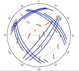
The time taken for a low-orbit satellite to orbit the earth is much shorter than that of a medium or high-orbit satellite. In the same time period, the trajectory is longer and the geometric configuration changes rapidly. Theoretically, the operation of a low-orbit satellite for 1 minute is equivalent to the geometric change of the current medium-orbit satellite for 20 minutes. The orbital characteristics of low-orbit satellites help to accelerate the convergence time of high-precision positioning, reaching 1-minute convergence, and the user experience is better. In the below figure, the trajectories of low-orbit satellites and middle-orbit satellites in the same time, where red is the middle-high orbit satellite trajectory, blue is the low-orbit satellite trajectory.
(4) Higher information rate, can broadcast more precise correction information
As the power of the ground signal increases, the low-orbit enhanced signal can carry a higher information rate or a larger signal bandwidth, and serves as a broadcasting channel for basic satellite navigation messages and differential correction messages.
(5) Miniaturization, integration, low power consumption of the terminal, easy for users to use
The enhancement of low-orbit enhanced signal power is conducive to the use of smaller terminal equipment by ground users; at the same time, for communication use, ground users can be normally received by low-orbit satellites with smaller signal power.
2. Help to build GNSS global space-based monitoring network
(1) Achieve high-quality global monitoring of satellite navigation signals
Compared with the ground monitoring network, the observation of low-orbit satellites on navigation signals has the characteristics of being less affected by the ionosphere and troposphere, the tracking arc length is longer, the coverage is more, and the multipath effect is less affected. As a high-precision space-based monitoring station for GNSS, low-orbit satellites can greatly improve the observation geometry, weaken the correlation between tangential orbit and phase ambiguity, improve the accuracy of orbit and clock difference of navigation satellites, and effectively make up for the space coverage of ground-based monitoring networks. On the shortcomings to achieve high-quality global monitoring.
(2) Can effectively improve the accuracy of satellite orbit determination
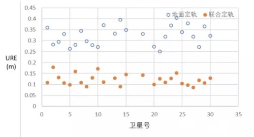
Through the selection of 30 navigation satellites, the orbit determination capabilities of only ground monitoring stations, and low-orbit satellite-based monitoring and ground joint monitoring are simulated and analyzed. Only ground monitoring stations perform orbit determination of space signals with an accuracy of about 0.3 meters; plus 12 low-orbit satellites to form space-based monitoring stations for joint orbit determination simulations, the signal accuracy is about 0.1 meters. Preliminary analysis shows that the ground-based and space-based joint monitoring and orbit determination based on the low-orbit constellation can increase the constellation orbit determination accuracy by more than double. Below figure is the comparison results of ground orbit determination and ground-based space-based joint orbit determination.
3. Help to provide global quasi real-time high-precision services
(1) Diversification of high-precision positioning service providers and hierarchical service models
At present, high-precision positioning services (precise single-point positioning, PPP) mainly include two types of commercial PPP services and PPP services embedded in satellite navigation systems.
In recent years, with the increasing demand for high-precision applications in the industry and the general public, European Galileo, Japanese QZSS and Chinese Beidou also have embedded design and provide PPP services in satellite navigation systems. Galileo provides free PPP services based on E6B signals, with a broadcast rate of 500bps. It enhances the GPS and Galileo systems to achieve decimeter-level positioning. QZSS precision positioning is divided into two types of sub-meter enhanced services (SLAS) and centimeter-level enhanced services (CLAS), both of which are free services provided by L1 and L6 signals, of which the CLAS service broadcast rate reaches 2000bps, which can simultaneously Five systems, GNSS and QZSS, were enhanced. The BeiDou system in China uses GEO satellites to provide high-precision positioning free services to users in China and surrounding areas. The broadcast frequency is B2b and the rate is 500bps. Real-time decimeter-level and post-centimeter-level positioning is achieved.
(2) The accuracy enhancement of low-orbit satellites has fast convergence characteristics, which can improve the high-precision user experience
At present, the PPP service provided by GNSS through medium or high orbit satellites, due to its slow orbital change, usually takes 15 to 30 minutes to converge. Although Japan’s QZSS system uses PPP-RTK technology to reduce the convergence time of PPP services to less than one minute, it needs a large number of highly dense ground monitoring stations, and thousands of monitoring stations need to be built within the territory of Japan alone. Low-orbit satellites have global GNSS high-precision monitoring capabilities, and have large geometric changes, making it easy for high-precision positioning to quickly converge. Relevant research shows that the convergence time of PPP service of satellite navigation system can be shortened to less than 1 minute after the integration of low-orbit satellite constellation, and users can obtain high-precision services quasi-real time.
4. Help to provide global high integrity monitoring services
1) Each satellite-based enhancement system currently provides regional integrity services
Integrity service refers to timely alerting users when navigation satellites fail and risk to improve the user’s ability to use safety. It is especially important for civil aviation and other users involved in life safety.
At present, the satellite-based augmentation systems (SBAS) mainly include the FAA Wide Area Augmentation System (WAAS), the European Geostationary Satellite Navigation Overlay Service System (EGNOS), China’s Big Dipper-based Augmentation System (BDSBAS), and the Russian Differential Correction and Monitoring System (SDCM), Japan Multifunctional Satellite Augmentation System (MSAS), India GPS-assisted Geostationary Orbit Augmentation Navigation System (GAGAN), South Korea Satellite Augmentation System (KASS) system, etc., all broadcast differential correction numbers to a certain area Enhance GNSS accuracy and integrity.
2) With higher quality space-based integrity monitoring capabilities
Through the GNSS global space-based monitoring network of low-orbit constellations, space-based monitoring of the integrity of navigation satellites can be achieved, and the orbital characteristics of low-orbit constellations are protected from ionospheric and tropospheric influences, and multipath effects are also smaller than on the ground. Can improve the ability to monitor the integrity of navigation satellites.
3) Integrity alert information can be broadcast globally
In the future, the user’s demand for SBAS services will not only be satisfied regionally, but will expand globally. The global coverage characteristics of LEO constellations make it naturally capable of broadcasting global integrity services.
